Civil Protection is on alert, expecting the "cold lake" front
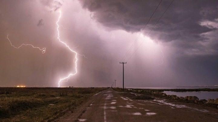
Specifically, the extreme and dangerous phenomena are expected to affect most of the country from today with heavy rains and storms, hail and gale force winds.
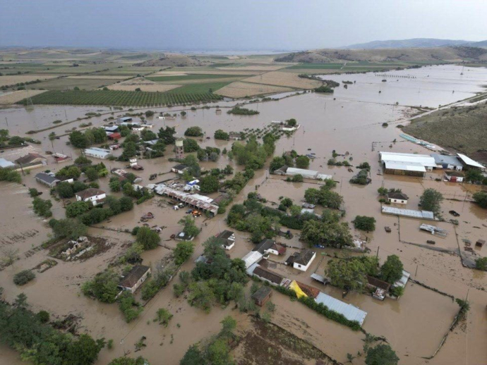
The state apparatus is in the "red", taking into account the update of the emergency notice of dangerous phenomena, with the highest levels of rain received by Thessaly, Sporades, central and eastern Sterea, northern Evia and the Peloponnese.
The latest forecast spoke of worsening weather with a noticeable drop in temperature. A barometric low from the northern Balkans with cold air masses is predicted to move south (to the southern Ionian) and will affect most areas of our country.
New meeting today in Civil Protection
There is great concern in the Ministry of Civil Protection about the possibility of flooding with the local government on its feet, especially in areas affected by fires. In fact, at the end of yesterday's meeting, it was decided to hold a new meeting for today, Monday, immediately after the update of the EDEKF by the National Meteorological Service.
The escalation of bad weather is expected on Tuesday and Wednesday with heavy rains and storms in Thessaly and Central Greece. It is noted that all the personnel of the Fire Department and Civil Protection are staffed and equipped with all the vehicles of the specific services to provide assistance where it is needed.
What is a "cold lake"
According to the National Observatory of Athens, the "cold lake" - as the specific phenomenon that will affect the country is called - brings extreme situations during the summer throughout Europe, which our country experienced strongly in the summer of 2019 and especially in July of that year in the region of Halkidiki.
One of the conditions to create storms in the summer is to have cold air masses high in the atmosphere, combined with high humidity. At the same time, it should be clarified that it is not necessarily linked to climate change, but it is an extreme situation that has been happening in recent years mainly in central Europe and the northern Balkans.
In "alert" status and a message from 112
High vigilance, full readiness and activation of 112 was requested, among others, by Vassilis Kikilias at the emergency meeting held at the Ministry of Climate Crisis and Civil Protection. The minister underlined that "the entire Civil Protection mechanism is on high alert" and stressed to all participants the "need for full preparedness" in order to take the necessary preventive measures and to deal immediately with any problems that may arise due to the upcoming dangerous weather phenomena.
Mr. Kikilias requested that special attention be shown since the dangerous phenomena will affect most areas of the country. In the context of the meeting, it was decided to activate 112, if deemed necessary to send warning messages to specific areas depending on the evolution of the phenomena.
At the same time, citizens are strongly advised to be very careful, to follow the instructions of the authorities and to take all the necessary self-protection measures, in accordance with the instructions of the Public Health Service.
Strong recommendations to citizens:
Citizens are advised to be particularly careful, taking measures to protect themselves from risks arising from the occurrence of severe weather phenomena, the general secretariat of Civil Protection addresses in view of the deterioration of the weather.
In particular, in areas where heavy rains, storms or gale-force winds are predicted, the Public Health Service recommends that citizens:
To secure objects which, if carried away by severe weather conditions, may cause damage or injury.
Make sure that the gutters and downspouts of the houses are not blocked and are working properly.
Avoid crossing torrents and streams, on foot or by vehicle, during storms and rainfall, but also for several hours after the end of their event
Avoid outdoor work and activities in marine and coastal areas during severe weather events (risk of lightning strikes).
Take shelter immediately during a hailstorm. Take shelter in a building or car and do not leave the safe area until they are sure the storm has passed. Hail can be very dangerous for animals too.
Avoid passing under large trees, under posted signs and in general areas where light objects (e.g. pots, broken glass, etc.) can become detached and fall to the ground (e.g. under balconies) .
To faithfully follow the instructions of the local authorities, such as Traffic, etc.
In areas with intense lightning activity:
If you are at home
Do not hold electrical appliances or the telephone as lightning can pass through the wires. Disconnect the TV sets from the antenna and the power supply.
Avoid touching plumbing pipes (kitchen, bathroom) as they are good conductors of electricity.
If you are in the car
Park it on the side of the road and away from trees that might fall on it.
Stay inside and turn on your stop warning lights (emergency lights) until the storm clears.
Close windows and do not touch metal objects.
Avoid flooded roads.
If you are outdoors
Take refuge in a building or car or sit on the ground immediately without lying down.
Take cover under solid branches of low trees if you are in the woods.
Never take shelter under a tall tree in an open area.
Avoid low-lying lands for the risk of flooding.
Do not stand next to utility poles, power lines, telephone lines and fences.
Do not approach metal objects (eg cars, bicycles, camping equipment, etc.).
Stay away from rivers, lakes or other bodies of water.
If you are in the sea, get out immediately.
If you're isolated on a flat surface and feel your hair stand on end (signaling that lightning is about to strike), sit deep with your head between your legs (to minimize your body surface area and contact with the ground ) by throwing the metal objects you have on you.
In addition, the general secretariat of Civil Protection (civilprotection.gov.gr) of the Ministry of Climate Crisis and Civil Protection, has informed the competent government agencies involved, as well as the regions and municipalities of the country, so that they are on increased civil protection readiness, in order to immediately deal with the effects of the occurrence of severe weather phenomena.
At the same time, as the Fire Department states in its announcement, the operational plans are being implemented to deal with the risks of flooding, as well as their accompanying phenomena, while the fire department remains on general alert, in order to immediately deal with any problems arising from the event of severe weather phenomena.
It is noted that according to the Emergency Bulletin of Dangerous Weather Phenomena (EDEKF) issued today by the National Meteorological Service (EMS), the weather in our country will deteriorate from Monday 4-9-2023 to Wednesday 6-9-2023 with heavy rains and storms that will be accompanied by hail and a high frequency of lightning, with increased winds and a noticeable drop in temperature. A barometric low from the northern Balkans with cold air masses is predicted to move south (to the southern Ionian) and will affect most areas of our country.
Thessaly, Sporades, central and eastern Sterea, northern Evia and the Peloponnese will receive the highest amounts of rain.
Citizens can be updated daily on the development of extraordinary weather phenomena in the regular weather reports of EMY and on the website of EMY at the online address www.emy.gr.
For information and announcements regarding the prevailing situation and the passability of the road network due to the inflow of flood waters, citizens can visit the EL.AS website. www.astynomia.gr.
For more information and self-protection instructions from severe weather, citizens can visit the website of the General Secretariat of Civil Protection at civilprotection.gov.gr.
The EMY forecast until Friday (8/9)
The weather report of the National Meteorological Service with the forecast until Friday, September 8, describes the development of the bad weather, with Monday (4/9), Tuesday (5/9) and Wednesday (6/9) to be the most dangerous days.
Particularly:
On Monday, September 4, the weather will worsen from the north with heavy rains and storms that will be accompanied by hail and a high frequency of lightning. Specifically from the midday hours in western and central Macedonia and temporarily in eastern Macedonia and Thrace. From the midday hours in Epirus, Thessaly, Sporades and gradually in the Ionian Islands, Sterea and Evia and from the early afternoon in the Peloponnese (mainly the west and the north). From late afternoon the phenomena will be limited to central Macedonia (mainly in the prefectures of Pieria and Imathia).
In the rest of the areas, sparse clouds that will gradually thicken and in the evening in the southeast there will be local rains and late at night possible isolated storms.
Winds will blow from north directions 4 to 6 and in the seas locally 7 Beaufort. In the northern Aegean in the evening they will strengthen to 8 Beaufort, while from the late afternoon in the southern Ionian they will turn to east southeast 4 to 6 Beaufort.
The temperature will drop significantly mainly in the north and in the west and in central Macedonia it will not exceed 24 degrees, while in eastern Macedonia and Thrace it will reach 26 to 28 degrees Celsius. In the rest of the country it will reach 28 to 30 degrees and in the southern island country in places 31 degrees Celsius.
On Tuesday, September 5, clouds with rain and sporadic storms are expected throughout the country. The phenomena will be strong in central Macedonia (mainly in the prefectures of Pieria, Imathia and Halkidiki), Thessaly, the Sporades, central and eastern Sterea (mainly in the prefectures of Evrytania, Fthiotida and Boeotia and temporarily in the prefecture of Attica, mainly in the west and north its parts), Evia (mainly the north), eastern and southern Peloponnese and western Crete. It will also be strong at times until the afternoon in Epirus, the Ionian Islands, western Sterea and western Peloponnese, as well as in the western Cyclades and the northern and eastern Aegean islands from midday to evening.
The winds will blow east northeast 5 to 7 and in the northern Aegean locally 8 Beaufort and only in the southern seas will blow east southeast 4 to 6 Beaufort.
The temperature will drop slightly mainly in the west and south reaching 21 degrees in the west and 23 degrees in the south, while in eastern Macedonia and Thrace it will reach up to 24 degrees Celsius. In the rest of the country it will reach 24 to 26 degrees and in the eastern island country in places 29 degrees Celsius.
On Wednesday, September 6, in the eastern island country, temporarily increased cloudiness with local rains and gradual improvement is forecast. In the rest of the country increased clouds with local rains and sporadic storms, strong in places in Thessaly, the Sporades, central and eastern Sterea, northern Evia, eastern and southern Peloponnese and western and southern Crete. From the evening the phenomena will weaken except for the regions of Thessaly and the Sporades.
Winds will be east northeast 4 to 6 and on the seas locally up to 7 Beaufort. The temperature in small increase.
On Thursday, September 7, a few clouds are forecast in the north and east of the island country, locally increasing at noon and in the afternoon. In the rest of the country, temporarily increased clouds, with local rains in the mainland and the south where temporary storms will occur, which in Thessaly and the Sporades will be strong in places in the morning hours. The effects will gradually fade. The winds will blow east northeast 4 to 6 and in the seas locally 7 Beaufort. The temperature will rise slightly further.
On Friday, September 8, generally clear weather is expected with a few temporarily increased clouds, mainly in the morning hours with the possibility of light rain in the central and northern areas.
The winds will blow east northeast 4 to 6 and in the seas locally 7 Beaufort. The temperature will not change appreciably.
EMY: The weather by region for today Monday
The EMY has published on its website the weather report for Monday 4 September, which shows the areas that will be most affected by the impending change in weather.
Attica
Weather: Sparse clouds that will quickly thicken and from midday there will be local rains and sporadic storms mainly in the west and north.
Winds: Northerly 4 to 5 and easterly to 6 Beaufort. Temperature: From 20 to 30 degrees Celsius.
Thessaloniki
Weather: Increased clouds with rain and sporadic storms which from the midday hours will be strong in places. In the evening the phenomena will temporarily weaken. Winds: Northerly 3 to 4 Beaufort. Temperature: From 19 to 24 degrees Celsius.
Macedonia, Thrace
Weather: Clouds with rain and storms initially in western and central Macedonia and quickly in the rest. The phenomena will be intense from the midday hours in western and central Macedonia and temporarily in eastern Macedonia and Thrace. From late afternoon the phenomena will be limited to central Macedonia (mainly in the prefectures of Pieria and Imathia). Winds: East North East 3 to 5 Beaufort turning quickly to North directions at the same intensity. From late afternoon in the east they will strengthen to 5 to 6 and in the seas late at night locally 7 Beaufort. Temperature: From 18 to 26 degrees Celsius. In western and central Macedonia 4 to 5 degrees lower.
Ionian Islands, Epirus, Western Sterea, Western Peloponnese
Weather: A few clouds that will quickly increase from the north and rains and storms will occur which will be strong from noon in Epirus, gradually in the Ionian Islands, in the western mainland and from the early afternoon in the western Peloponnese. Winds: From easterlies 3 to 5 Beaufort and in the Ionian north northwest 4 to 6, off the Ionian locally up to 7 Beaufort. By late afternoon in the southern Ionian they will turn to east southeast 4 to 5 Beaufort. Temperature: From 18 to 30 degrees Celsius. In the interior of Epirus 3 to 4 degrees lower.
Thessaly, Eastern Sterea, Eastern Peloponnese
Weather: A few clouds that will quickly increase from the north and rains and storms will occur which will be strong from midday in Thessaly, the Sporades, gradually in eastern Sterea, Evia and from the early afternoon in the Peloponnese (mainly in the north ). Winds: Northerly 3 to 5 and easterly to 6 Beaufort. Temperature: From 17 to 30 degrees Celsius. In the north the maximum is 3 to 4 degrees lower.
Euboea
Weather: A few clouds that will quickly increase and there will be local showers and scattered thunderstorms, which from midday and from the north will be strong. Winds: Northerly 4 to 5 and southerly 6 Beaufort.
Temperature: From 20 to 27 degrees Celsius.
Cyclades, Crete
Weather: Sparse clouds that will gradually thicken and local rains will occur in the afternoon. Winds: Northerly 4 to 6 Beaufort with weakening from the evening hours. Temperature: From 23 to 30 and in southern Crete locally up to 31 degrees Celsius.
Eastern Aegean Islands - Dodecanese
Weather: Initially generally sunny. From the north, sparse clouds that will gradually thicken and local rains will occur, and from the afternoon in the Dodecanese islands, isolated storms may occur. Winds: Northerly 4 to 6, moderate to northerly local to 7 Beaufort. In the Dodecanese, from midday the winds will gradually turn southerly at 3 to 5 Beaufort. Temperature: From 22 to 31 degrees Celsius.