Mandatory anti-slip chains from tonight in Attica - Snow in the mountains of Evia
In particular, as highlighted in the announcement, for special safety reasons in order to avoid causing traffic problems and due to the occurrence of adverse weather conditions, with decisions of the Traffic Police Directorate of Attica and the Police Directorate of Boeotia, will not be allowed to traffic all kinds of heavy vehicles of maximum permissible weight of more than 3.5 tons, regardless of the use of anti-slip chains from 22: 00΄hour on 28-01-2024 until the phenomena subsides on both traffic streams P. E.E.O. Elefsina - Thebes from the 5th km (REVOIL petrol station - former CYCLON) of Attica to the 34th of E.E.O. Elefsina - Thebes of Boeotia.
The following are excluded from the above prohibition:
-Road assistance vehicles.
-Vehicles carrying salt.
-Emergency vehicles.
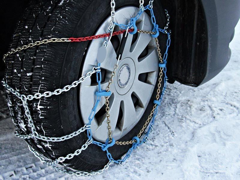
In addition, by decision of the Director of Traffic Police of Attica, from 22:00 on Monday night (29/1), cars of all categories must be equipped with anti-slip chains or other similar anti-slip means, if these vehicles do not have special tires when driving on the entire road network of the prefecture of Attica.
Furthermore, due to the imminent outbreak of severe weather phenomena.
Snow in the mountains of Evia - Schools will not operate until Wednesday in the Municipality of Mantoudiou - Agia Anna and Limni
The snow has made its appearance in the mountains of Evia and it is already snowing since Sunday night in the villages of Seta and Steni, while snowfall will intensify today, Monday and Tuesday.
The entire forces of the Region of Central Greece and the municipalities have been put on alert, but so far there are no problems.
In "red" alert are also the machines in southern Fthiotida and the municipalities of Kamena Vourla and Lokron, while in Martino have gathered many snowplows to intervene when needed.
As announced, schools in the municipality of Mantoudi - Agia Anna and Limni will be closed as a precautionary measure from Monday until Wednesday. It is noted that in cases where face-to-face classes are not held due to bad weather, classes will be held online.
As for the other areas of Evia, depending on the extension of the phenomena, decisions will be taken in the morning.
The Risk Assessment Committee for the bad weather meets again today, Monday at 12:00
Professionalism and seriousness from all called yesterday Sunday the Minister of Climate Crisis and Civil Protection, Vassilis Kikilias, in view of the bad weather, after the conclusion of successive meetings held in the Civil Protection. Earlier, the Risk Assessment Committee met, followed by an Inter-ministerial Committee meeting on the worsening weather and operational coordination of all stakeholders.
Mr. Kikilias advised everyone to be careful and avoid travel in areas that will be affected by bad weather, while he noted that a new meeting of the Risk Assessment Committee will be held today, Monday at 12 noon, where final decisions will be taken on any traffic restrictions.
As Mr. Kikilias said, this is a bad weather, which it seems will hit - mainly on Tuesday and possibly from the evening hours of Monday, and may extend to Wednesday - areas of Attica, Attikovoitia, part of Magnesia, Thessaly, Evia and Crete.
EMY: Where there will be snowfall
Snowfall in mountainous and semi-mountainous areas of Thessaly, Sporades, central and eastern Sterea, Euboea, northern and eastern Peloponnese and from noon onwards in areas of lower altitude. Snowfall will occur in the mountainous areas of the Aegean islands and in the mountainous areas of Crete.
GENERAL CHARACTERISTICS
In the eastern mainland and in the Aegean local rain or sleet and in the sea and coastal areas thunderstorms. From noon onwards, the phenomena will be locally strong mainly in the Sporades, Evia, the Cyclades and Crete. Snowfall will occur in mountainous and semi-mountainous areas of Thessaly, Sporades, central and eastern Sterea, Evia, northern and eastern Peloponnese, Crete and in the mountainous areas of the Aegean islands. From noon in Thessaly, Sporades, eastern Sterea, Euboea and eastern and northern Peloponnese, snowfall will intensify and snow will also fall in areas with lower altitude (indicatively 300-400m).
In the rest of the country, a few clouds in Macedonia and Thrace where light snowfall will occur.
Winds will blow in the west east northeast 3 to 5 Beaufort and in the east north northeast 4 to 6 and in the Aegean 7 and locally 8 Beaufort.
The temperature will drop slightly further, mainly in the east. It will range in the central and northern areas from -05 (minus 5) to 08 to 09 degrees Celsius, in the rest of the continent from -02 (minus 2) to 12 degrees and in the islands from 05 to 12 degrees Celsius.
In the morning and evening hours in the continental areas there will be frost, which will be strong in the north.
MACEDONIA, THRACE
Weather.
Winds: North northeastern 4 to 6 and in the east locally 7 Beaufort.
Temperature: From -03 (minus 3) to 09 degrees Celsius. In western Macedonia 3 to 4 degrees lower.
IONIAN ISLANDS, EPIRUS, WESTERN SOLID, WESTERN PELOPONNESE, WESTERN PELOPONNESE.
Weather: a few local clouds.
Northwestern Greece: Eastern northeastern 3 to 5 Beaufort.
Temperature: From -02 (minus 2) to 12 degrees Celsius. In the interior of Epirus 3 to 4 degrees lower.
EASTERN SOLIDIA, EUBOEA, EASTERN PELOPONNESE
Weather. Snowfall will initially occur in the mountains and semi-mountains, which will intensify from midday and snow will also fall in areas of relatively low altitude (about 300-400m).
Winds: North northeast 4 to 6 Beaufort, in the east 7 and gradually up to 8 Beaufort.
Temperature: From -02 (minus 2) to 08 degrees Celsius.
CYCLADES, CRETE
Weather: clouds with local showers and occasional thunderstorms, from noon onwards, occasionally heavy in places. Snowfall will occur in the mountains and in the semi-mountainous areas of Crete (around 600m).
Winds: North northeastern 6 to 7 and gradually in places 8 Beaufort.
Temperature: From 05 to 10 degrees.
EASTERN AEGEAN ISLANDS - DODECANESE
Weather: a few clouds, partly cloudy with local showers and isolated thunderstorms. Snowfall will occur in the mountains of the eastern Aegean islands.
Winds: North northeastern 6 to 7 and gradually locally 8 Beaufort.
Temperature: From 07 to 12 degrees Celsius. In the north 3 to 4 degrees lower.
THESSALY
Weather: cloudy with local rain or sleet and in the Sporades sporadic thunderstorms. From noon onwards, the phenomena will be occasionally strong in the Sporades. Snowfall will occur in mountainous and semi-mountainous areas, which will intensify from noon and at night snow will also fall in areas of relatively low altitude (about 300-400m).
Winds: From northern directions 4 to 6 and in the Sporades up to 7 Beaufort.
Temperature: From -03 (minus 3) to 08 degrees Celsius.
ATTICA
Weather. Snowfall will occur in mountainous and gradually in semi-mountainous areas which will intensify from the evening and at night snow will fall in areas of relatively low altitude (indicatively 300-400m).
Winds: North northeast 4 to 6 and in the east 7 Beaufort.
Temperature: From 03 to 08 degrees Celsius.
THESSALONIKI
Weather.
Sunny, light breezes: North northwestern 4 to 6 and in the morning up to 7 Beaufort.
Temperature: From -01 (minus 1) to 08 degrees Celsius.
FORECAST FOR TOMORROW TUESDAY 30-01-2024
In the eastern and southern part of the country, clouds with rain or sleet and in the sea and coastal areas, sporadic thunderstorms mainly in the Sporades, Evia, Cyclades and Crete. Snowfall will occur even in areas with lower altitude in Thessaly, the Sporades, central and eastern Sterea, Evia, eastern and northern Peloponnese, as well as in mountainous and semi-mountainous areas of the northern and eastern Aegean islands, the Cyclades and Crete.
In the rest of the country, a few clouds are forecast for the rest of the country.
Winds will blow north northeast, in the west 4 to 6 Beaufort, in the east 6 to 8 and in the Aegean 8 to 9 and locally up to 10 Beaufort.
The temperature will remain low and will range in the north from -06 (minus 6) to 09 degrees Celsius, in the rest of the western continent from -03 (minus 3) to 12, in the eastern continent from -03 (minus 3) to 10 and in the island country from 05 to 13 degrees Celsius.
In the morning and evening hours on the continents there will be frost, which will be locally heavy in the north.