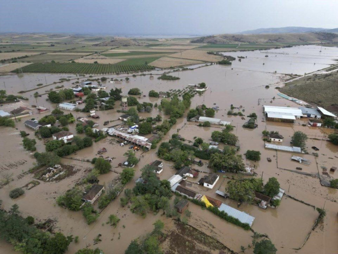
"Genesis" storm: Call for attention due to extreme events by Civil Protection Service
At the same time, the ministry addresses a strong recommendation to the citizens in the areas that are expected to be affected to follow the following basic instructions faithfully:
- We avoid any unnecessary movement during severe weather conditions and secure your doors and windows tightly, always keeping in mind in case of torrents to move to the highest points of the house.
- We NEVER cross torrents, streams or flooded roads, on foot or by vehicle. For no reason!
- We follow the relevant announcements in the media and we always follow the instructions of the Authorities.
Instructions for protection:
The General Secretariat for Civil Protection (www.civilprotection.gr) of the Ministry of Climate Crisis & Civil Protection, has informed the competent State services involved, as well as the regions and municipalities of the country, in order to be on increased alert for civil protection, in order to deal immediately with the effects of severe weather.
At the same time, the General Secretariat for Civil Protection advises citizens to be especially careful, taking care of self-protection measures against the dangers arising from the occurrence of severe weather phenomena.
In particular, in areas where heavy rainfall, storms or stormy winds are forecast:
Insure items that, if swept away by severe weather, could cause damage or injury.
Make sure that the gutters and gutters of the houses are not blocked and are operating normally.
Avoid crossing torrents and streams, on foot or by vehicle, during storms and rainfall, but also for several hours after the end of their event
Avoid field work and activities in the sea and coastal areas during severe weather events (risk of lightning strikes).
Take immediate precautions during a hailstorm. Take refuge in a building or car and do not leave the safe area until they are sure that the storm is over. Hail can also be very dangerous for animals.
Avoid passing under large trees, under hanging signs and generally in areas where light objects (eg pots, broken glass, etc.) can come off and fall to the ground (eg under balconies). .
To faithfully follow the instructions of the locally competent bodies, such as Traffic, etc.
Also, in areas where there is intense lightning activity:
If you are at home:
Do not hold electrical appliances or telephone as lightning may pass through the cables. Disconnect the TV sets from the antenna and the power supply.
Avoid touching the plumbing pipes (kitchen, bathroom) as they are good conductors of electricity.
If you are in the car:
Immobilize it on the side of the road and away from trees that may fall on it.
Stay inside and turn on the stop lights (emergency lights) until the storm stops.
Close the windows and do not touch metal objects.
Avoid flooded roads.
If you are outdoors:
Take refuge in a building or in a car, otherwise sit immediately on the ground without lying down.
Protect yourself under solid low tree branches in case you are in a forest.
Never take refuge under a tall tree in the open.
Avoid low ground for the risk of flooding.
Do not stand next to pylons, power lines, telephone lines and fences.
Do not approach metal objects (e.g. cars, bicycles, camping gear, etc.).
Stay away from rivers, lakes or other bodies of water.
If you are in the sea go out immediately.
If you are isolated on a flat surface and feel your hair stand up (indicating that lightning will soon occur), do a deep seat with your head between your legs (to minimize your body surface and contact with the ground ) throwing the metal objects you have on you.
For more information and instructions on self-protection from severe weather conditions, citizens can visit the website of the General Secretariat for Civil Protection at:
www.civilprotection.gr.
The emergency bulletin of EMY
Extreme weather events are starting in the country, with EMY upgrading the emergency bulletin of worsening weather to an emergency bulletin of dangerous weather phenomena.
Specifically, as EMY warns, a barometric low will be created in the Ionian which will move east and will cause the bad weather "Genesis" which will mainly affect western, central and northern Greece from today Thursday (09-06-2022) until Saturday night (11-06-2022) with heavy rains and thunderstorms that will be accompanied by hail, high frequency of lightning and strong winds.
More details will be affected:
On Thursday (09-06-2022)
From the afternoon the northern Ionian, Epirus, western Sterea, Macedonia, Thessaly and from the evening probably Thrace.
On Friday (10-06-2022)
a. The Ionian Islands, Epirus, western Sterea and western Peloponnese (mainly Achaia and Ilia). At night the effects will weaken.
b. From the first hours Macedonia, Thrace and the islands of the northern Aegean and gradually Thessaly, the Sporades, eastern Sterea and northern Evia. At night the phenomena in western Macedonia, western Thessaly and eastern Sterea will weaken.
On Saturday (11-06-2022)
a. Central and eastern Macedonia, eastern Thessaly, the Sporades, Evia, Thrace, the islands of the northern Aegean and gradually the islands of the eastern Aegean and the Dodecanese. From the evening the effects will weaken.
b. The noon and afternoon hours will be temporarily affected by
Epirus, western Macedonia, Sterea (including
Attica) and the eastern Peloponnese.