Weatherstorm "Barbara": Snow in Attica from Sunday - Recommendations to restrict movement - New meeting today
According to the bulletin, the snowfall will start in the early hours of the morning from the islands of the northern Aegean and by noon will affect both Thrace and Halkidiki.
The snow will spread further south before noon, intensifying and affecting the Sporades, eastern parts of Thessaly, Evia and eastern Sterea, especially Boeotia and Attica. In fact, as the updated EMY emergency bulletin states, "snowfall will occur even in the plains of these areas". From Sunday afternoon, snowfall will occur in Crete as well as in the Aegean islands.
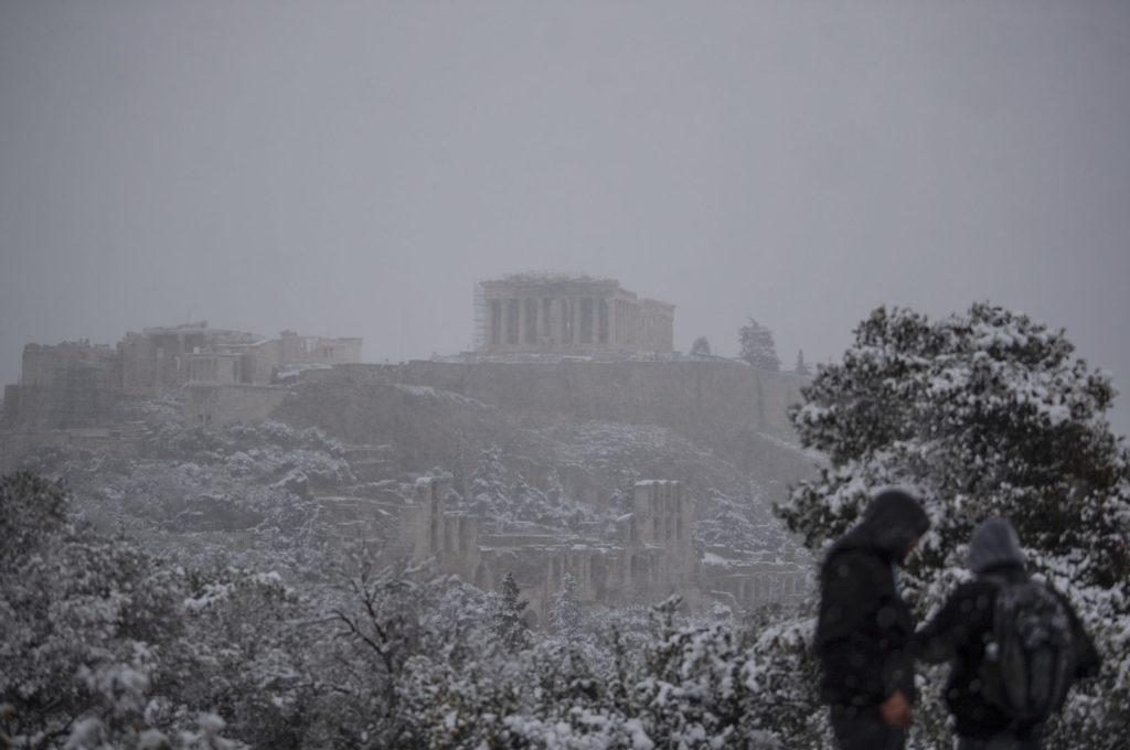
The snowfall in Attica As pointed out in the EMY bulletin, especially for Attica, snowfalls will occur from Sunday (05/02/2023) initially in the east and the north, which from the midday hours will spread to most of the prefecture while from the afternoon they will intensify and it will also snow in lowland areas.
Snowfall will show a temporary lull overnight. However, from Monday morning the snowfall will intensify again throughout the prefecture. The drop in temperature will also be significant as from Sunday a gradual drop in temperature from north to south is expected, of the order of 8 to 10 degrees. Strong recommendation to limit travel.
Yesterday, Friday, the press representative of the Hellenic Fire Brigade, fire chief, Ioannis Artopioos, in an emergency briefing, addressed a strong recommendation to the citizens to limit their movements to those absolutely necessary in view of the bad weather, noting at the same time that "it is extremely possible that the traffic of heavy vehicles will be prohibited in areas with special snowfall". He also emphasized that it is now mandatory to equip all vehicles with anti-slip means and added that ELAS will carry out strict checks from Saturday morning.
Activation of emergency phone number 112 will be sent to specific areas depending on the evolution of the phenomena.
Accordingly, in a broad coordination meeting held yesterday at the Ministry of Climate Crisis and Civil Protection under the Minister Christos Stylianidis with the participation of co-competent ministers of the physical leadership of the fire brigade, all involved bodies, the National Meteorological Service, as well as a scientific team of meteorologists, it was decided the activation of 112 to send warning messages to specific areas depending on the evolution of phenomena. At the same time, it was mentioned that, in areas with heavy snowfall, it is highly possible that the traffic of heavy vehicles will be prohibited. As the minister underlined, the entire civil protection mechanism is being put on the highest alert and vigilance in order to deal immediately with any problems that arise due to the upcoming dangerous weather phenomena. New meeting today A new meeting will be held today with the participation of the president of KEDE, representatives of the Regions and highway concessionaires that will be affected by the bad weather.
The Bulletin of the EMY
In detail, the updated EMY Dangerous Weather Bulletin issued today states the following: The Emergency Weather Bulletin issued on 03-02-2023/13:00 local time is updated according to the latest forecast data. It is pointed out that there are no substantial differences from the original bulletin. More specifically, Cold air masses from northern Europe will move further south and cause bad weather with the name BARBARA in our country from Sunday (02/05/2023). The main features will be the low temperatures, the strong frost, the locally dense snowfalls even in lowland areas of eastern Greece, as well as the stormy northerly winds of intensity 8 to 9 Beaufort on the seas.
Snowfalls:
A) On Sunday (05/02/2023) they will be affected by snowfall 1. From the early hours of the morning the islands of the northern Aegean and until noon Thrace and Halkidiki. 2. Before midday the snowfall will spread further south, intensify and affect the Sporades, the eastern parts of Thessaly, Evia and eastern Sterea, especially Boeotia and Attica. Snowfall will occur even in the lowlands of these areas. 3. From the afternoon, snow will fall in the mountains - semi-mountains mainly of the central and northern Cyclades as well as Crete. In Crete, the snowfall will be heavy at times. 4. Snow storms will occur mainly over the sea and coastal areas of the Aegean.
B) On Monday (06/02/2023) at times heavy snowfall will continue to occur on the northern Aegean islands, the Sporades, Evia, eastern Sterea, the Cyclades and Crete.
C) Especially for Attica, snowfall will occur from Sunday (05/02/2023) initially in the east and the north, which from the midday hours will extend to most of the prefecture, while from the afternoon it will intensify and it will snow in lowland areas. Snowfall will show a temporary lull overnight. However, from Monday morning the snowfall will intensify again throughout the prefecture.
D) On Tuesday (07/02/2023), snowfall is expected to continue in eastern Greece from Thessaly and further south (rainy areas) as well as in the Cyclades and Crete, but with less intensity.
Low temperatures From Sunday (05/02/2023) a gradual drop in temperature from north to south is expected, of the order of 8 to 10 degrees. This will result in the prevalence of strong frost mainly in the continental areas, which will be total in places in the central and northern areas (negative temperatures throughout the day).
Stormy Winds From Sunday (02/05/2023) at noon, stormy north-northeast winds of intensity 8 to 9 Beaufort will blow on the seas, which from Sunday afternoon in the Ionian and from Tuesday (02/07/2023) in the Aegean, gradually they will weaken.